
 English
- Català
- Español
- Français
 Follow us


English
- Català
- Español
- Français

SEARCH
Follow us
![[Tancar]](/plantilles/bergueda/img/tancar.png)
Family and nature routes

Stroll around El Grauet
Introduction
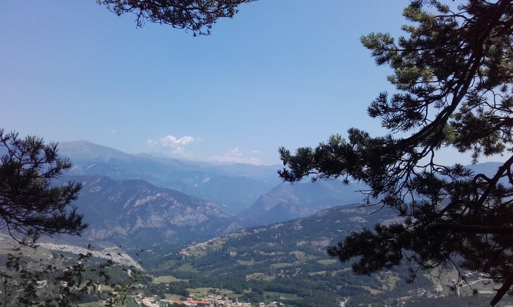
This itinerary invites you to climb through a leafy pine forest to enjoy spectacular views of the Vallcebre valley and the southern slope of the Parc del Cadí Moixeró. The steep and rocky nature of the upper area allows for various adventure activities. After passing the Canalassa pass, it offers new views of the Ensija baga, the paleontological sites and vestiges of the area's mining past.
The QR code you will find in the brochure, will link you to the application "Camins de Vallcebre", to know historical, natural and landscape aspects of this route.
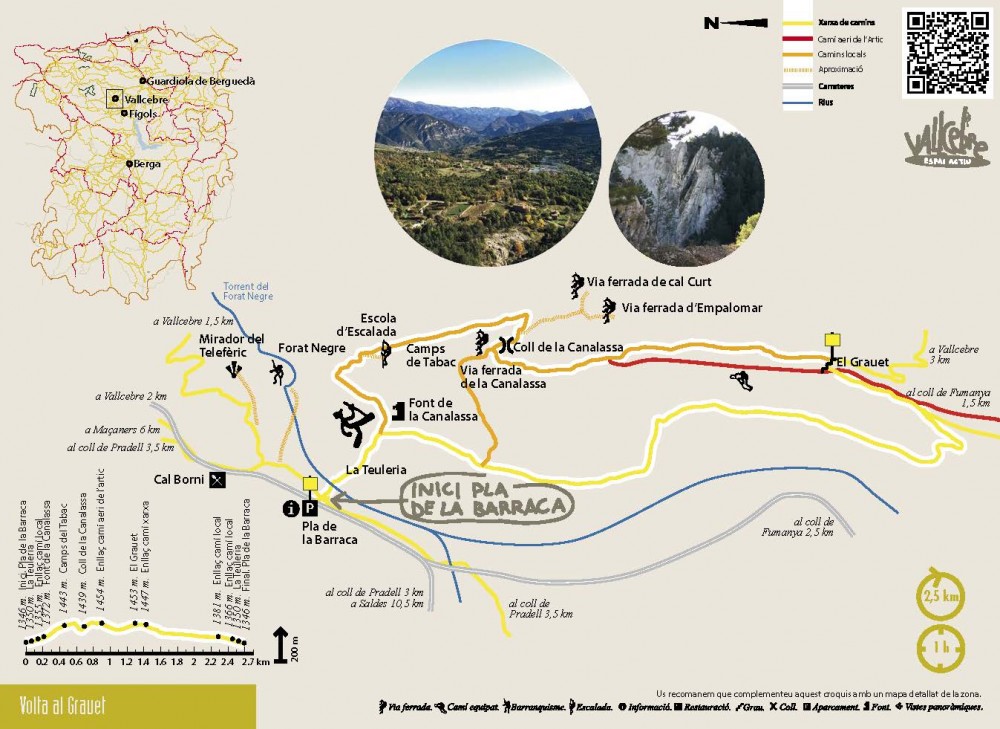
Description of the route
The route starts at Pla de la Barraca, before the fork of the road that goes from Vallcebre to Saldes or to Fígols. From this same place you can access the Vallcebre Active Space. From the car park you must cross the stream to Gual and climb the path that goes directly in front. When you start climbing, you will find on the right hand side the remains of the Canalassa roof tile. The path continues up through the pine forest. After about a hundred meters you will find a fork that you will have to follow to the left and soon you will find the Font de la Canalassa and then you will leave the path on the right which will take you to the climbing area. By zigzagging you will come to flat strips known as the tobacco fields as they were formerly cultivated. The views over the Cadí Moixeró from this point are spectacular. At the end of these bays, the path descends gently to return to the Canalassa pass, the starting point of the via ferrata of the same name.
At this point you have to take the path that goes left, heading south, known as the "Oriola path". The path climbs and begins a half-height flank along this ridge. If until now the views were to the east, from here another perspective opens to the west. You will pass under the Empalomar via ferrata, below the monkey bridge and continue down gently. You will leave on the right the place where the Camí aeri de l'Àrtic begins, and continue on the Oriola road until you reach a junction of paths, where you have to continue on the right and after making just four steps to stand. to the Grauet, a small passage that allows to cross to the other slope of the mountain.
Some 200 meters further on, you will find a fork in the path, following the one on the right, down. From here the path turns to the right to take the north direction and begin the return that will take you directly to the Pla de la Barraca, the end point of the itinerary.
Technical sheet
Route number: 49
Town: Vallcebre
Type: Very easy
Distance: 2,5 km.
Time: 1 hora.
maximum altitude: 1462 m.
height difference: 225 m.
To organise
Cartography: 46-Parc Natural del Cadí-Moixeró E. 1:25.000. Institut Cartogràfic i Geològic de Catalunya Rasos de Peguera - Serra d’Ensija 1:25.000. Ed. Alpina
More information
Bibliography: App per mòbil: Camins de Vallcebre Inventari de Patrimoni: patrimonicultural.diba.cat
Documents and links
OFICINA DE TURISME DEL BERGUEDÀ
Carretera C16 Km 96
08600-Berga. Phone (+34) 654 125 696
Monday to Friday: 9 to 14h.
Saturday: 10 to 14 & 16 to 18h.
Sunday and holidays: 10 to 14h.
E-mail: turisme@elbergueda.cat
![]()
ACKNOWLEDGMENTS

[Premsa]
Other


Follow us


