
 English
 Follow us


![[Tancar]](/plantilles/bergueda/img/tancar.png)

La Dou del Bastareny


Gisclareny is a municipality with a scattered population. By the middle of the nineteenth century there were about 120 farmhouses spread over its territory, most of them in great poverty. Hikers in the early twentieth century agree to describe the village as a place where misery reigned, with subsistence agriculture in stony fields. However, they all talked about the beauty of the Bastareny valley and the houses there. This route crosses some of the communication routes between the houses of the valley, today all abandoned, and the nucleus of the municipality, in a setting of great scenic beauty within the natural park of the Cadí-Moixeró.
Description
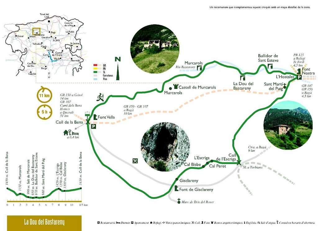
The route starts in front of the Font Nostra, in the neighborhood of the Hostalet, where there is Cal Cerdanyola, which now houses the Aula de Natura la Salle. Some time ago there was a mill - now in ruins - that used the waters of the Pendís river. Upstream where the Vents de Cadi Refuge is now, the structure of a 16th-century farmhouse, the Hostalet's house, can be seen with subsequent additions due to its use as a hostel on the Camí Ral de la Cerdanya.
Follow the track in the direction of the Dou del Bastareny - you can shorten it by the path on the right that saves the bend of the track where the parking area is. You will soon cross a bridge across the river, the Bastareny. Next to it are the ruins of the old flour mill of Forat or Puig, built at the end of the s. XVII or beginnings of the s. XVIII; not the first mill of the Bastareny, on the return you will see the remains of what was located a few meters from the birth. At the next bend you have to leave the track to go along the old road on the left that will take you directly to the first important farmhouse on this route, the house of Puig. Cited already in documents of the Middle Ages, the current building dates from the 18th century. It has the peculiarity of having a roof with four waters, of exemplary numbers in the Berguedà. Following the path on the left will take you to the small Romanesque church of Sant Martí del Puig. As you climb up, you will have views of Bagà. Look behind the church for a stone with a footprint that looks like a foot, it is called the Footprint of the Virgin.
Returning to the house of Puig, follow the track until the next junction of tracks, where you have to climb the path that goes up the ridge to Coll de Escriga, with some sections now converted to forestry. When you are at the pass, without reaching the road, follow the track on the right that goes through the forest and in a less accentuated way, it goes up to a meadow where the landscape changes. You are over the neighborhood of Berta and in the background is the majestic Pedraforca massif. When you cross the meadow, you will see piles of stones scattered throughout. They are not there by accident but have been piled up year after year to keep the fields clean. When you see these piles of stones it is an unmistakable sign that there were former fields. To the right of the meadow, half hidden in the woods, is the house of Escriga and just before going down, behind the signposts, are the ruins of Cal Peret, crushed by huge stones detached from the limestone wall . When descending you need to be careful as loose stones abound in the middle of the road and it is easy to fall.
After about 100 meters down, the road divides. The signposted route continues to the left, but if you follow the path that goes straight, you will turn a rock and you will see a huge cavity: Cal Bisbe, a formerly inhabited cave. You can still see some stones from the walls and the traces of the smoke on the rock walls. It was abandoned in the second half of the 19th century and now serves as a shelter for goats.
Keep going down and you will pass the first houses in the Berta district, cross the road and a path will take you to the recreational area of the Gisclareny fountain; a good place to rest for a while and refill the bins, if needed. Continue on the road that goes up to the village, and in a closed bend, continue straight on along the track towards Coll de la Bena. But before that, if you have time it is worth going up to the church and the district of El Roser, which you will see above the hill. The church is documented from the s. XIV as a church in the castle of Gisclareny, because the parish was the neighboring church of St. Miquel de Turbians. The medieval construction was replaced at the end of the s. 17th or early 18th century for the current Baroque building.
The track continues skirting pastures until reaching the scattered district of Coll de la Bena. Follow the track to the right and once on the tarmac, follow it to the left. You are at an important crossroads, you must continue towards the Bastareny valley, on the path that goes down to the right. Follow the same path as the Camí dels Bons Homes (GR 107) and GR 150 meters. The path will soon take you to the Font Vella, a beautiful place and a good opportunity to refill or refresh. Soon, the GRs are on the right and you have to follow the left until you find a track that, without leaving it, will take you to Murcurols; another of the great farmhouses in the valley. The house is documented since the Middle Ages, although the current structure is of modern age, but a set of additions are clearly visible. The northern face, dating to the medieval period (12th-13th centuries), could be part of a church. Already in documents of the s. XII also speaks of a castle in this place, in the ridge to the east there are some remains that could be part, but in any case it is totally devastated. This is an excellent place to enjoy the view, which extends from the Bauma pass to the west, Tancalaporta, the Moixa mountain range, the Moixeró, and the Cortalets pass below Tancalaporta, to the Vimboca hole opposite. and the Stones a little further east. On the opposite side of the mountain, there is an unmistakable depression of the terrain, wide above and narrow below. It is the Chamber of the Bocs where lambs were closed after mating so that they would not disturb the sheep and the young.
Once you have resumed the path, return to the crossroads and take the path to the left of the house to descend to the bottom of the valley. After a stony descent where you have to be careful not to slip, you cross the stream. If it is a wet season, you will hear the Salt de Murcurols, which you can access after passing the stream, by a path on the left a few meters. A nice jump, especially when the horsepower drops; notice how the pumice sedimented in times of drought has formed a waterslide. Continuing along the path, you must cross the Muga stream, which descends from the Moixeró range.
You will exit on a track that will have to follow to the right. Shortly afterwards, you will pass underneath the house of Monnell or Molnell, another of the large farms in the area that if you pay attention you will see on the way down. This one is documented from the s. XIV and for a time they dominated and exploded the headwaters of the Bastareny river. Continue on the main track and after crossing the waters of the Bastareny through the Monnell bridge, you can climb the well-marked path to the Dou del Bastareny. The leap is photographed on countless postcards.
At the exit of the stream, it seems that a flour mill had been later converted into a sawmill. In the early twentieth century, when it was a sawmill, logs were transported by cable car to Bagà.
Continue along the main track and later on you will find the access to the Bullidor de Sant Esteve on the left. If you want you can go down there, which leads to springs on the riverbed - more visible in times of little water. You have to be careful with the descent; there are quite high steps and with the humidity they slip easily. Continue on the signposted path, and on arriving at the path that you have already done, you will see a small booth on the right from where there is water noise. It is the source of the Violin, whose water is now brought to Bagà. And from here you know, cross the Bastareny, the ruins of the mill and a little climb to get back to Cal Cerdanyola, the end of the route.
Technical sheet
Route number: 6
Town: Gisclareny
Type: Middle
Zone: Gisclareny
Starting point: Coll de la Bena - 1.450 m. (Gisclareny). La ruta també es pot començar des del poble de Gisclareny o des de Cal Cerdanyola (inici de la ruta dels Empedrats).
Ending point: Coll de la Bena - 1.450 m. (Gisclareny)
Distance: 13,5 Km.
Time: 4,5 h.
maximum altitude: 1437 m.
height difference: 825 m.
Signals: Marques verdes i blanques en tota la ruta
To organise
Cartography: 46-Parc Natural del Cadí-Moixeró E. 1:25.000. Institut Cartogràfic i Geològic de Catalunya Moixeró - La Tosa 1:25.000. Ed. Alpina
More information
Recommended by: Ca l'Amagat Rustic gastrohotel / Refugi Vents de Cadí
Bibliography: Les Tres-centes cases de Gisclareny de Francesc Caballé. Ed. l'Albí Inventari de Patrimoni: invarquit.cultura.gencat.cat
Documents and links
- Llibre de ruta la Dou del Bastareny
- La Dou dels Bastareny GPX 2020
- La Dou del Bastareny EARTH 2020
- L'Adou del Bastareny
[TambeInteressar]
- >

- >
OFICINA DE TURISME DEL BERGUEDÀ
Customer service opening hours:
from Monday to Friday from 9 am to 2 pm.
on public holidays falling from Monday to Friday from 10 am to 2 pm.
Tel. +34 654 125 696
E-mail: turisme@elbergueda.cat
![]()
ACKNOWLEDGMENTS

[Premsa]
Other


Follow us


