
 English
- Català
- Español
- Français
 Follow us


English
- Català
- Español
- Français

SEARCH
Follow us
![[Tancar]](/plantilles/bergueda/img/tancar.png)
Family and nature routes

Un tomb per la Nou
The peasantry, the livestock, the mines and the mills have always been closely linked to the village of La Nou. In each house you could find a miner and a farmer, and women working in the fields, helping the mines, and taking care of the animals. About 15 mines were in operation in the township between 1900 and 1962. Some of the last mills, which closed at the same time as the mines, have been operating since the 14th century.
A walk around La Nou is a short hike that will bring you closer to these environments and also to the sanctuary of Lurdes, the grotto and the fountain, combining small paths and forest tracks.
Description
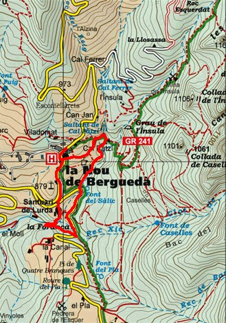
The route starts at the public car park in front of the social premises and the town hall of La Nou. Follow the road down to Cal Batlló, where you have the option of following the route directly by taking the tarmac road that descends to the left and down to the sanctuary of La Nou, or before climbing to Tossal, The hill that you have to the right and from where you can enjoy good and original views.
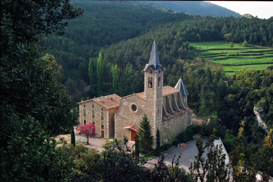
Whether you choose one or the other then you have to follow the paved track to the Sanctuary of Lurdes de Nou. According to the record, Mossèn Antoni Comellas, son and rector of La Nou, ill, went to Lurdes in 1877; there he lived a great experience of faith. He returned the following year, bearing an image of Our Lady, which he placed in a chapel near where the sanctuary is now. The event was well known throughout Berguedà and many devotees went up to visit it: a shrine was needed. The work began in 1880 and was inaugurated in 1885. The inn was erected in 1893. To commemorate the 75th anniversary (1960), the belfry was built. It is the first shrine of the Virgin of Lurdes that was erected in Spain.
From here, on the rectory side, follow the stairs that will lower you to the grotto by steep steps (you must be careful). Here, Father Antoni Comellas, imitating the deeds of Lourdes, renamed the small fountain of Sant Isidre that was near the stream to Font de la Mare de Déu (1881). Taking advantage of the rock, the Grotto was modeled where an image of the Virgin was placed. And even a small spa was built there; In the annals of the sanctuary some healing is attributed, attributed to the Virgin and to the water of this fountain.
The route goes through an iron gate that you will see at the bottom and then you will find a fork that you have to follow first on the right to approach the Molí de l'Avellanosa, a construction in a very small space. As early as 1572 it is mentioned in some parish documents, which could be in the same place. A few meters below is the building called the mill, s. XVII, at present private house.
We must return along the same path and continue now towards the Molí de la Canal. At this point, it is necessary to carefully observe the environment, in the direction of the stream and to the right, to see the mill raft, now full of land and vegetation. In the background, to the left, small hills indicate what is left of the walls and the vaults of the old mill. You will find a panel with a schematic drawn to help you get the idea. These are similar works, probably from the same period as the Molí de l'Avellanosa.
We follow a path until we find the road that comes from Vilada and follow it to the left. Immediately you will find Cal Torrent and, following the road, when you reach a sharp bend you will see the Sàlic fountain on your right. Once past the fountain and the bridge over the road you have on the stream, the path climbs to the right on a path that follows the stream of La Nou until you reach Cal Patzi. Once here, follow the path to the left, passing a bridge over the stream and the fountain of Cal Patzi. It is a shady and pleasant place to pause and watch the water jumping. The return journey to return to the point of origin can be done in two ways: a softer one that is following the track that passes through cal Lledoner and the church of Sant Martí; the other more direct is by climbing the path that goes to the right (following the GR 241 markings) and which will take you directly to the end point of the route.
Technical sheet
Route number: 43
Town: La Nou
Type: Very easy
Zone: Catllaràs
Starting point: Aparcament públic de la Nou
Ending point: Aparcament públic de la Nou
Distance: 2,5 Km
Time: 1 h.
maximum altitude: 883 m.
height difference: 150 m.
Signals: Plaquetes de color verd amb una franja granate amb el títol
To organise
Cartography: Berga 1:25.000. Institut Cartogràfic de Catalunya. Catllaràs - Picancel 1:25.000. Ed. Alpina
More information
Bibliography: Inventari de Patrimoni: invarquit.cultura.gencat.cat
Documents and links
[TambeInteressar]
- >

- >
OFICINA DE TURISME DEL BERGUEDÀ
Carretera C16 Km 96
08600-Berga. Phone (+34) 654 125 696
Monday to Friday: 9 to 14h.
Saturday: 10 to 14 & 16 to 18h.
Sunday and holidays: 10 to 14h.
E-mail: turisme@elbergueda.cat
![]()
ACKNOWLEDGMENTS

[Premsa]
Other


Follow us


