
 English
 Follow us


![[Tancar]](/plantilles/bergueda/img/tancar.png)

Fígols i la vall de Fumanya
The historical past of this corner of Berguedà has been marked by coal mining. On this route you will be able to see two characteristic elements of this activity: the remains of various mines and the tracks of dinosaurs. You can round off the route with a visit to the Cercs Mining Museum where you can explore this dark and little-known world in greater detail.
Description
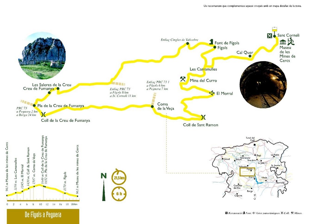
The route starts in front of the Cercs Mines Museum and heads south along the Llobregat trail (GR 270). The track will soon stop being paved as it heads west towards Fígols. You will pass by some dustbins and the houses of the Quer and Cal Gorra, and on the next turning you will leave the GR marks and to follow the ones of the PR-C 73, by the track to the right that now will rise of courage, towards Cal Calderer. When you reach the paved track, follow it to the left until the charming nucleus of Fígols, currently one of the least densely populated municipalities in Catalonia; few inhabitants and lots of land. Notable is the Romanesque church of Santa Cecília (XI - XII)
Once you have drunk and refreshed if you need the fountain, you will find just after the town hall the fork in roads; Follow the asphalted track towards Coll de la Veça, here you will see the path that goes up to the right, where you will return.
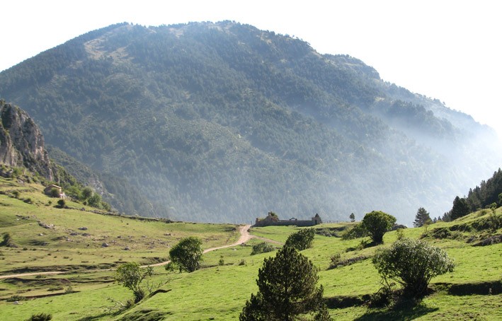
You will descend gently past the cemetery and the uninhabited house of Cal Sant. Here the asphalt continues to the left towards the Fountain of the Parera, but you have to follow the track on the right and a little more than half a kilometer, in a closed bend to the right, leave it and follow the one that goes from the left making a change of slope. Then you will see the remains of some buildings and the mouth of the Curro, which shows the past mine in the area
Following the path of Fígols obaga, you will pass stretches of steep and others of softer, but always with a tendency to go up. El Morral, the pass of Sant Ramon, and as far as the Coma de Veça where there is a plain with three or four ponds. To the right of the second pond is the neck with a fork in paths. If you need it you could cut the route here and join the path on the right that joins this PR with the variant of Fígols, in the Torrent del Peu de l'Obaga where you will return. If the proposal is good, but you have to come to the Creu de Fumanya. So continue on the track on the left which will lead you up slightly. Along the way you can enjoy some interesting perspectives of the Ensija mountain range and the old open-cast mine in Vallcebre where the dinosaur footprints are located.
Once at the Colladal Mercadal, the path begins to descend until the Pla de la Creu de Fumanya. At this point you will connect with the old road to Peguera, which you must follow on the right to go again to Fígols. Towards the left the road leads to the old mining town of Peguera. If you have the time and energy you can reach it and enjoy the tranquility of this valley. It will take you about an hour to get there.
To return to Fígols, from Pla, pass the chain and follow the track to the right, which starts to descend. From now on you will follow the PR-C-73.1. You will leave the house of the Cross of Fumanya on your left and begin to descend to the stream that you cross to follow its course on its right side. You will come to a point where you will find the path that goes directly from Coma de Veça.
After leaving several tracks and paths to the right and left you will reach the asphalted road to Peguera. You will have to cross it and continue on the track for Cal Petit, past the house keep going down and at the next fork, follow the track on the right that will return you to the road. Follow it here about 200 m to the left and you will find the path on the right that will lower you again to the village of Fígols.
From here you will only have to undo the path you have come when you come to Cal Calderer, Cal Cap and El Quer, the powder shops and continue descending until you reach the Museum of Mines car park again.
Technical sheet
Route number: 10
Town: Fígols
Type: Difficult
Starting point: Sant Corneli.
Ending point: Sant Corneli.
Distance: 22 Km.
Time: 7 h.
maximum altitude: 1746 m.
height difference: 875 m.
Signals: Marques grogues i blanques
To organise
Cartography: 5-Berga. 1:25.000 Institut Cartogràfic i Geològic de Catalunya Rasos de Peguera - Serra d’Ensija 1:25.000. Ed. Alpina
More information
Bibliography: Terra de carbó, guia de la ruta minera de R. Serra, A. Prat i J. Picas. Ed. Zenobita Inventari de Patrimoni: invarquit.cultura.gencat.cat
Documents and links
[TambeInteressar]
- >

OFICINA DE TURISME DEL BERGUEDÀ
Customer service opening hours:
from Monday to Friday from 9 am to 2 pm.
on public holidays falling from Monday to Friday from 10 am to 2 pm.
Tel. +34 654 125 696
E-mail: turisme@elbergueda.cat
![]()
ACKNOWLEDGMENTS

[Premsa]
Other


Follow us


